Day 2: Strathfarrar
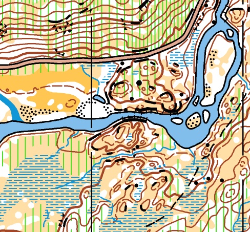
Strathfarrar map extract
Monday 3rd August
PDF of the all results (useful for searching for club members)
Photo galleries: ActivNorth, Wendy Carlyle
Glen Strathfarrar is new to orienteering, and gives a unique opportunity to sample this rugged and beautiful glen, which extends for many miles.
For those familiar with Munro climbing, it is well known that only 25 cars a day are allowed into this glen and only on certain days in the week. Access to the area is controlled by a locked gate. Because of the narrow road with few parking places, and use of other fields for sheep and a deer farm, parking will be 2km to the east of the Race Arena.
Two areas are being used for the competition: Culligran, on the north side of the River Farrar, and Struy, on the south side. Culligran is rough, tough and technical with few line features. Struy is less rough, with more (but limited) line features and the terrain is easier than Culligran. To enable the two areas to be linked, two bridges are being constructed - a 36m floating bridge (walkway) opposite the Race Arena that will take two-way pedestrian traffic, and a smaller bridge upstream (at Neaty Beach), which is one-way.
Location

Nearest town: Struy
- Postcode: IV4 7JT
- Lat/Lon: 57.42624,-4.66267
- Google Map
- Streetmap (OS)
- Bing Map (OS)
- OpenStreetMap
Organising clubs: Mar Orienteering Club (MAROC), Roxburgh Reivers Orienteering Club (RR), with Southern Navigators orienteering Club (SN)
Day Organisers: Jon Musgrave (MAROC), John Tullie (RR)
Planners: Martin Wilson (BKO), Roger Scrutton (ESOC)
Assistant Controller: John Biggar (RR)
Controller: Blair Young (TINTO)
This day's competition will be the 12th event in the 2015 UK Orienteering League.
Travel: Please follow these travel directions to reach the event. There may be other possible routes but this is the route agreed with local police and other relevant official bodies.
From Inverness, follow A862 10 miles to junction with A831 SW of Beauly. Turn L and follow A831 9 miles to Struy Bridge. Turn L into parking field.
Last arrival by 12:30. No Exit before 12:30.
Distances between locations
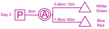
Parking: Fields 2km from Race Arena.
Race Arena: 2km from car parking along a flat tarmac private road. The Race Arena is in a large flat field north of the River Farrar, with room for club tents. A very limited minibus shuttle service between the parking field and the Arena will be provided for competitors in M/W80 and older classes, children under 6 and their immediate family and those with special disabled permits. This service will run from as soon as possible after 0845 from the parking field until approximately 1645 from the arena.
Starts: White/Green - south of the river, across a floating pontoon bridge. There is a marshalled crossing of the competition run-in after 300m. Blue/Red - west of the Race Arena along road and track. The latter stages pass through the competition area; competitors must stay on the marked route. Limited toilets on route to Red/Blue Start.
Neither Start is accessible for buggies.
Finish: South of the river, 100m from the Race Arena, with Download and all other event infrastructure north of the river across the bridge.
Map: Stirling Surveys 2014, updated 2015.
Terrain: A new area to orienteering, largely birch woodland and semi-open moorland, with small areas of intricate rock and contour detail. Very few paths. Varying runnability, toughest is high on the steeper N side. The S side is also well contoured, with some plantation. Red and Blue courses cross the River Farrar via a temporary bridge.
String course: within 100m of the entrance to the Arena, across the private road. This road crossing will be marshalled, and the route is accessible for buggies.
Safety Information: The road to the Arena and Blue/Red Start is a single-lane private road with passing places. Little traffic is expected, but take care and allow cars to pass through.
The river level can change very quickly if the hydro-dam is opened for power creation or due to high water levels. Check final details for any impact.
Special Information: The competition area is part of a large shooting estate, with an extensive wild deer population. Competitors should check very carefully for ticks after their run.
Colour coded EOD: Green is significantly longer and more technical than Light Green. If in doubt which of these to enter, perhaps it would be wise to choose the latter.
[alternative keywords: final details, bulletin, day-2]
Strathfarrar map extract (Full size)

Strathfarrar terrain (Full size)