Day 5: Glen Affric
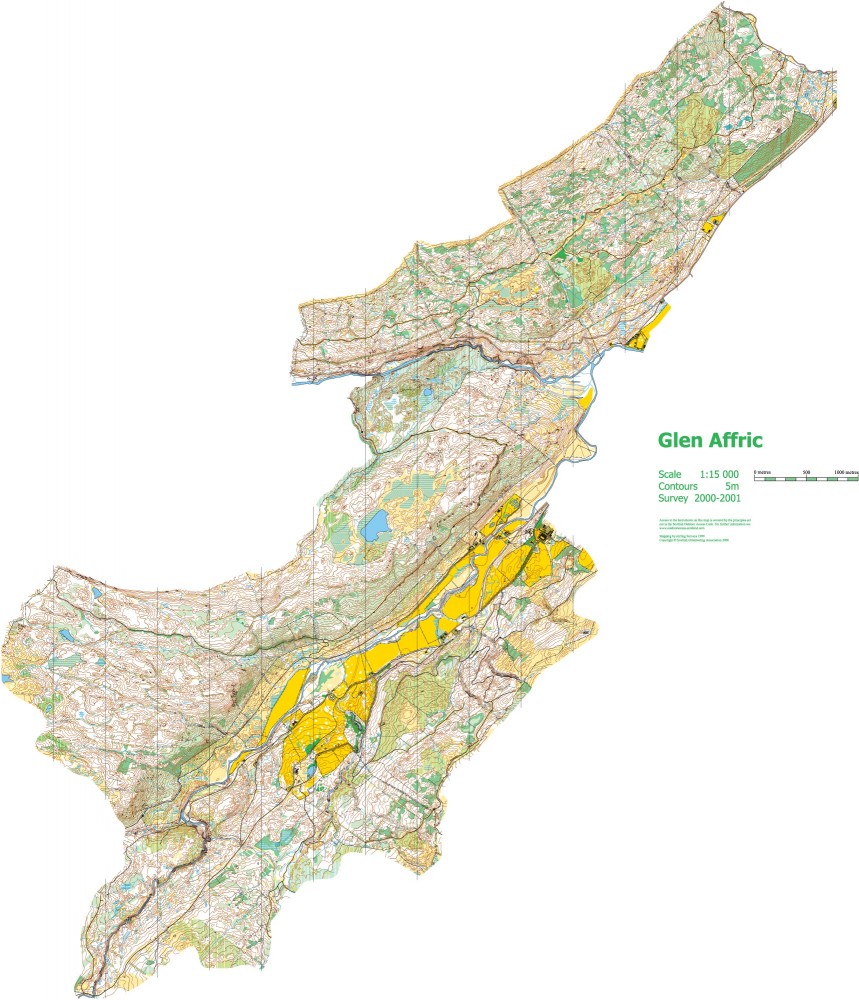
Glen Affric map
Friday 7th August
Due to a synchronisation discrepancy of 7 seconds in the finish units on Day 5, the final timings of all affected competitors were corrected overnight.
Photo Galleries: ActivNorth, Wendy Carlyle
A big thank you to all the last minute volunteers who helped us on Day 5. We could not have done it without you. Especially the people who had to man a gate in case the cows escaped and never saw a cow all day.
Gareth and David (Day 5 Organisers)
Location

Nearest town: Tomich
- Postcode: IV4 7LY
- Lat/Lon: 57.30216,-4.81661
- Google Map
- Streetmap (OS)
- Bing Map (OS)
- OpenStreetMap
Glen Affric has been used for previous WOC and Scottish 6 Days events and is one the best examples of the Caledonian Forest that once covered much of Scotland.
Glen Affric is commonly agreed to be one of the finest of Scotland’s glens.
Two distinct parts of the area are being used for the event, separated by the river Abhainn Deabhag. A permanent footbridge across the river has been constructed, with assistance from the Royal Engineers, and a temporary footbridge into the arena is also being built. The maps of each part of the area have been extended to give access to new terrain not used before for orienteering.
The forest areas are predominantly owned by Forestry Commission Scotland.
Organising clubs: Forth Valley Orienteers (FVO), Badenoch & Strathspey Orienteering Club (BASOC), St Andrews (Glasgow) Orienteering Club (STAG), with Havering and South Essex Orienteering Club (HAVOC) and Pendle Forest Orienteers (PFO)
Day Organisers: Gareth Bryan-Jones (FVO), David Nicol (FVO)
Planners: Hilary Quick (BASOC), Jenny Clarke (BASOC)
Assistant Controller: Graham McFadyen (STAG)
Controller: Terry O'Brien (STAG)
Travel: Please follow these travel directions to reach the event. There may be other possible routes but this is the route agreed with local police and other relevant official bodies.
From Inverness, follow A82 for 14 miles alongside Loch Ness, to Drumnadrochit. Turn R on A831, 12 miles to Cannich. Follow minor road and tracks (O signs) 5 miles to Tomich and Wester Knockfin.
Last arrival by 12:00. No Exit before 12:30.

Distances between locations
Parking: Final 3km along narrow gravel track. Main car park is adjacent to Race Arena. Bus parking is a 500m walk from the Arena, though only 2km from Starts. Overflow car parking, if required, is a 2km walk from Arena, though only 500m from Starts.
Race Arena: Shared with WOC. The WOC Long Distance race has its Finish in the Arena. 6-Day download, results and traders will be adjacent to the WOC Arena.
Starts: Starts 2.7 km, leave car park over temporary footbridge. Mostly easy walking across fields and on tracks but not suitable for buggies. There are two Starts adjacent to each other: a White start and a combined Red, Blue and Green Start. There will be limited toilet facilities close to the Starts.
Finish: The 6-Day finishes are on the south side of the river, after finishing all competitors must follow directions to download in the Race Arena. There are 3 Finishes: one for the short, technically easy, courses from the White Start (1 km from Download), one for the shorter technically difficult courses (1.5 km from Download), and one for all the other courses (400m from Download).
Map: 2014 extension and revision by Deeside Orienteering and Leisure Maps (DOLM) of the 1999 map used for Day 4 of Highland ‘99.
Terrain: Mostly commercial forest with pockets of delightful native species, and with several deep-sided ravines. Crags at stream edges are well mapped and can be avoided with ease. Runnability has been reduced by recent windblow, most of which is shown on the map by a vertical green screen. Courses for youngest juniors are not affected.
String course: The String and Off-string courses are 200m from the main car park. The route to the String courses crosses a rough field, not suitable for buggies, and crosses the track being used by event traffic. The crossing will be marshalled. Children should be accompanied by an adult when walking to or from the String course.
Safety Information: All routes to the Starts have a section along the track being used by event buses. Please take care when walking to the start. Some very high crags near one ravine will be marked with yellow/black tape. All courses cross a minor, unmetalled, public road, however there is little traffic and it moves slowly.
[alternative keywords: final details, bulletin, day-5]
Glen Affric map (Full size)

Glen Affric map extract (Full size)